
What Do Migrating Birds Know That We Don’t? Discover the Power of GIS in Their Winter Escape to India
Bird migration is one of nature’s most spectacular phenomena. Every year, millions of birds embark on epic journeys, traveling thousands of miles across continents. Their destination? Warmer climates, abundant food sources, and safe breeding grounds. Among the most notable wintering regions in the world, India stands out as a crucial haven for migratory birds, especially during the colder months of the year. From the majestic Steppe Eagle in the north to the delicate bluethroat in the south, the diverse ecosystems of India — such as wetlands, grasslands, mangroves, forests, and plateaus — play host to an extraordinary variety of avian travelers. But what drives these birds to such far-flung destinations? And how do they navigate such vast distances with astonishing precision? While instinct has long been credited for guiding them, it is through the lens of technology — specifically Geographic Information Systems (GIS) — that scientists are beginning to unravel the true mysteries behind bird migration.
By integrating large volumes of spatial and environmental data, GIS helps researchers decipher the critical factors influencing migration patterns. It provides a comprehensive view of how geographical features, weather conditions, and food availability shape the migration strategies of birds. But perhaps the most remarkable aspect of GIS is its ability to visualize these migration routes, allowing scientists to map, track, and predict bird movements across the globe. In this blog, we will explore the power of GIS in unlocking the secrets behind the migration of birds to India and its significant role in conservation efforts aimed at preserving the habitats that these migratory species rely on.
The Role of GIS in Mapping and Understanding Migration Routes
Bird migration is not a random event. It is a complex, highly organized phenomenon shaped by a combination of innate instincts and environmental factors. Over the years, scientists have accumulated vast amounts of data to chart the migration routes of various species. However, it is through the use of GIS that these data points come to life. GIS allows researchers to integrate a multitude of variables, such as topography, climate, vegetation, and wind patterns, to create dynamic maps that visualize migratory routes in a spatial context. These maps provide insights into the factors influencing bird movements and allow researchers to make connections between geography and behavioral patterns.
In India, GIS has been used extensively to track the migration of waterfowl such as the Northern Pintail and Barred Buttonquail, which use wetlands as vital stopover sites during their long journeys from the cold northern regions. Wetlands, like the Keoladeo National Park and Chilika Lake, serve as essential breeding grounds and resting places for thousands of migratory birds. By overlaying GIS data of wetland areas with bird sighting data, scientists can pinpoint which areas are most heavily used by migratory species and determine the best strategies for preserving these vital habitats. The ability to visualize migration routes on GIS maps also provides valuable insights into the environmental changes that may threaten these habitats, such as urbanization, water pollution, and climate change.

The image above illustrates how the wind patterns in Maharashtra assist migrating birds. By utilizing these winds, birds can reduce their energy expenditure, as they glide along with the tailwinds to their wintering destinations, requiring less energy for the journey.
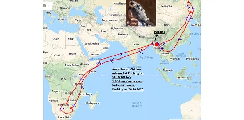
Researchers have used GIS tools to track the movements of the Amur Falcon across the Indian subcontinent. By examining how the Falcons use wind currents and avoid adverse weather conditions like cyclones, GIS models can predict the most energy-efficient paths and identify new migration routes in the face of changing climate patterns.
Mapping Environmental Drivers: Wind, Temperature, and Food Availability
GIS is not just about mapping bird movements; it is also about understanding the environmental drivers that influence these movements. These drivers include wind patterns, temperature fluctuations, and food availability — all of which are key factors in determining when and where birds migrate.
Wind Patterns: Many migratory species, including birds of prey like the Steppe Eagle and the Pallid Scops Owl, rely heavily on wind currents for energy-efficient migration. For example, raptors often use thermals — updrafts of warm air — to gain altitude without expending energy. GIS tools allow researchers to create dynamic wind models, showing how birds align their migration routes with favorable wind conditions. Wind currents can also impact the timing of migration, as birds adjust their schedules based on wind direction and strength. For instance, Steppe Eagles, migrating from Central Asia to India, often fly along mountain ranges and plains where thermal updrafts provide the lift they need to glide effortlessly for long distances.

Temperature: Temperature is another driving force behind bird migration. As temperatures drop in the northern breeding grounds, many birds, including the Eurasian Hobby and Bluethroat, head south to warmer regions, such as India. GIS allows researchers to track temperature gradients over large geographical areas, helping scientists understand how birds adapt to seasonal temperature changes and adjust their migration routes accordingly. GIS can also predict the timing of these migrations by correlating temperature shifts with the birds’ movement patterns.

Food Availability: A bird’s migration is often dictated by the availability of food. Species such as the Osprey, which feed on fish, must follow watercourses and coastal shorelines to find adequate food sources. GIS tools can integrate satellite imagery with ecological data to determine the abundance of food resources along migration routes. This allows scientists to identify critical feeding areas that birds rely on during their journey and understand how habitat loss or changes in the environment can affect their survival.

Example: GIS mapping has helped track the movements of Bar-headed Geese, which migrate across the Himalayas. By studying the temperature, vegetation, and food sources along their migration path, scientists can better predict their migratory timing and ensure the protection of key feeding areas like wetlands and rivers.
The Role of Real-Time Tracking and Citizen Science Platforms
With advancements in tracking technology, scientists can now follow migratory birds in real-time. Satellite tags and GPS devices have allowed for unprecedented insight into bird movements, providing detailed, up-to-the-minute data on migration routes. This data, when integrated with GIS, enables scientists to build accurate, predictive models of bird migration.

One of the key advantages of real-time tracking is the ability to observe how birds adapt their flight paths in response to weather changes, such as cyclones or storms. For instance, Black Storks may modify their flight route to avoid a storm, taking advantage of favorable wind conditions created by the cyclone’s movement. By incorporating real-time tracking data into GIS models, researchers can monitor these adjustments and gain a deeper understanding of how environmental factors affect migratory behavior.
Furthermore, citizen science platforms like eBird have become increasingly important in tracking bird migration. eBird allows birdwatchers to report sightings of migratory species, contributing valuable data to the scientific community. GIS can incorporate this citizen-generated data into broader migration models, helping scientists fill in gaps where tracking devices may be unavailable. By combining eBird data with satellite imagery and GIS analytics, researchers can get a fuller picture of bird migration patterns, including those in less accessible regions.
Example: Researchers have used citizen science data from eBird in combination with GIS tools to track the migratory patterns of Red Knot shorebirds. This has led to the identification of important stopover sites along the East Asian-Australasian Flyway, which are critical for the survival of these birds.
GIS and Conservation: Protecting Migratory Routes and Habitats
As climate change and human activity continue to threaten migratory bird populations, GIS plays a pivotal role in conservation efforts. By identifying key migration corridors and critical stopover sites, GIS helps prioritize areas for conservation. For example, GIS data has been used to map the migratory routes of the Bar-headed Goose in India, highlighting the importance of wetland ecosystems like Chilika Lake. These maps provide valuable information for conservationists working to protect these habitats from the impacts of climate change, pollution, and over-exploitation.
In addition to mapping migration routes, GIS also helps monitor the health of these critical habitats. For instance, by integrating data on water quality, vegetation, and bird populations, GIS can track changes in the health of wetlands and other ecosystems. This data helps scientists assess whether these habitats are becoming less suitable for migratory birds and informs restoration and protection strategies.
Example: GIS has been used to assess the impact of urbanization on migratory birds in cities like Mumbai, where wetlands are being converted into real estate developments. By mapping bird sightings and habitat changes over time, conservationists can advocate for the protection of these vital habitats and work with local governments to implement conservation policies.
Challenges and Future Directions
Despite the significant advances made in the study of bird migration using GIS, challenges remain. The accuracy of migration models depends on the quality and quantity of data, and not all species can be easily tracked due to their remote habitats or the lack of technology. Additionally, the complexity of migration — affected by factors such as weather, human activity, and food availability — means that GIS models are not always perfect predictors.
However, ongoing advancements in satellite technology, machine learning, and data integration are helping to overcome these challenges. As GIS tools become more sophisticated, the ability to track and predict bird migration with even greater accuracy will continue to improve.
Conclusion
The migration of birds is a marvel of nature, driven by a combination of environmental cues and innate behavior. GIS has emerged as a powerful tool for unlocking the secrets behind these extraordinary journeys. By mapping migration routes, analyzing environmental factors, and monitoring habitats, GIS allows scientists to understand how birds navigate vast distances and adapt to the challenges they face. As we continue to develop new technologies and collaborate globally, GIS will play an increasingly important role in conservation efforts, ensuring that migratory birds have safe and sustainable habitats in India and beyond.