
Introduction: A New Era for Wildlife Protection
India’s wildlife is a treasure trove of biodiversity, hosting some of the planet’s most iconic species, including the Bengal tiger, Asiatic elephant, and snow leopard. However, this natural heritage faces unprecedented challenges from habitat loss, climate change, and human-wildlife conflict. Amid these threats, technology offers a glimmer of hope, with Artificial Intelligence (AI) and Geographic Information Systems (GIS) leading the charge in wildlife conservation.
AI and GIS are not just tools; they are enablers of smarter, more efficient, and proactive conservation strategies. While traditional methods relied heavily on manual monitoring and reactive measures, these advanced technologies allow conservationists to predict challenges, map critical habitats, and act swiftly to protect wildlife. This blog explores how AI and GIS are shaping a brighter future for wildlife conservation in India, highlighting their potential to safeguard biodiversity for generations to come.
The Importance of Wildlife Conservation in India
India’s ecological richness is unparalleled, housing nearly 8% of the world’s biodiversity on just 2.4% of its land. This biodiversity is critical not only for maintaining ecological balance but also for supporting livelihoods, ensuring climate resilience, and preserving cultural heritage. However, the survival of India’s wildlife is increasingly under threat. From deforestation to poaching, the pressures are multifaceted and complex.
While traditional methods have helped conserve wildlife, they often struggle to keep up with the increasing complexity of today’s conservation challenges. These methods can sometimes be difficult to apply on a large scale.
This is where artificial intelligence (AI) and Geographic Information Systems (GIS) can make a real difference. These powerful tools combine valuable information with advanced mapping techniques. By automating tasks, improving the reliability of our data, and allowing us to make decisions quickly, AI and GIS are revolutionizing the way we protect wildlife.

Applications of AI and GIS in Wildlife Conservation
AI and GIS are being used in various ways to protect India’s wildlife. Here’s how these technologies are making an impact:
Tracking and Monitoring Wildlife
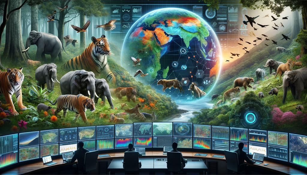
AI-powered image recognition tools analyze camera trap footage, identifying species and even individual animals based on their unique patterns. GIS adds another layer by mapping animal movements, identifying migration routes, and visualizing breeding and feeding grounds. For example, GIS-based tracking of tiger movements in Madhya Pradesh has enabled better corridor management, ensuring safe passage for these big cats across fragmented habitats. Specifically, in Madhya Pradesh, GIS has been instrumental in understanding tiger dispersal patterns and identifying critical corridors connecting different tiger reserves. By analyzing camera trap data, GPS collar data, and habitat characteristics within a GIS framework, researchers have been able to map tiger movement, identify key dispersal routes, and pinpoint areas where habitat fragmentation poses a threat to tiger populations. This information has been used to inform management decisions, such as the creation of wildlife corridors and the mitigation of human-wildlife conflict. Beyond tigers, GIS has also been used to track and monitor other endangered species in India. For instance, in the case of the Great Indian Bustard, GIS has been used to map their distribution, identify their breeding grounds, and assess the impact of habitat loss and fragmentation on their populations. This information has been crucial for developing conservation strategies and protecting their remaining habitats. Similarly, GIS has played a vital role in monitoring elephant populations in India. By analyzing elephant movement data, researchers can identify key migratory routes, assess human-elephant conflict hotspots, and develop mitigation measures to minimize negative interactions. These examples showcase how GIS, coupled with AI and other technologies, is revolutionizing wildlife tracking and monitoring, providing critical information for conservation efforts across India.
Habitat Mapping and Restoration
Satellite imagery, combined with AI algorithms, identifies areas of habitat degradation and prioritizes regions for restoration. GIS is instrumental in mapping these areas, allowing conservationists to implement targeted reforestation programs. In the Western Ghats, such mapping has been crucial for protecting critical biodiversity hotspots and restoring degraded forests. For example, in the context of the Western Ghats, GIS played a crucial role in mapping and analyzing the distribution of the endangered Lion-tailed Macaque. By integrating satellite imagery, field data, and spatial analysis tools, researchers were able to identify critical habitats, assess fragmentation levels, and develop conservation strategies. This information helped prioritize areas for reforestation and habitat connectivity, crucial for the long-term survival of this primate species. Similarly, GIS has been instrumental in mapping and restoring mangrove ecosystems along the Indian coastline. In the Sundarbans, a UNESCO World Heritage Site, GIS has been used to map mangrove extent, monitor changes over time, and identify areas vulnerable to erosion and degradation. This information is essential for implementing effective mangrove restoration projects, which provide vital coastal protection, support biodiversity, and sustain local communities. Beyond specific species, GIS is also used for broader habitat mapping and restoration efforts. For instance, in the Himalayas, GIS is being used to map forest cover, assess deforestation rates, and identify areas for reforestation and watershed management. These efforts are crucial for maintaining the ecological integrity of the Himalayan ecosystem and ensuring the long-term availability of water resources. These examples highlight the power of GIS in supporting habitat mapping and restoration initiatives across diverse ecosystems in India.
Anti-Poaching Efforts
Poaching remains one of the gravest threats to India’s wildlife. AI uses predictive analytics to identify potential poaching hotspots by analyzing data such as historical incidents, terrain, and animal behavior. GIS integrates these predictions with spatial data, enabling authorities to deploy anti-poaching patrols more effectively. This approach has been successfully implemented in Kaziranga National Park, home to the endangered one-horned rhinoceros.
Reducing Human-Wildlife Conflict
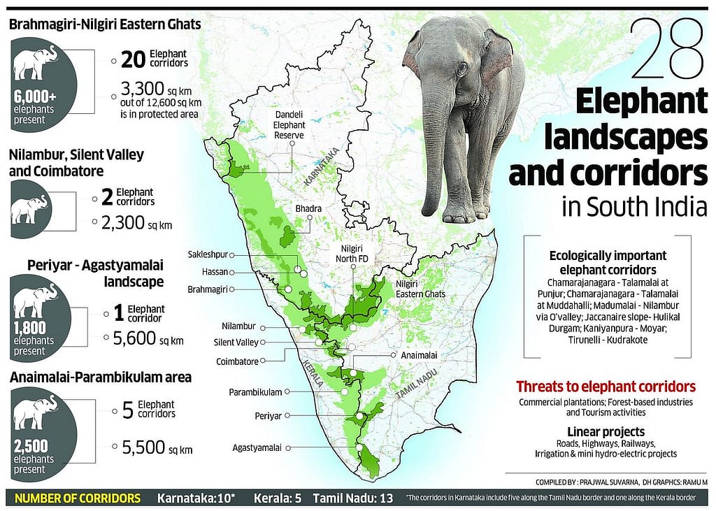
As urbanization encroaches on wildlife habitats, conflicts between humans and animals are on the rise. AI systems analyze patterns of human-wildlife interactions to predict conflict-prone zones. GIS visualizes these zones, helping local authorities implement preventive measures such as fencing, community awareness programs, and wildlife corridors. Such strategies have been employed in Uttarakhand to mitigate elephant-human conflicts. Elaborating on this, the increasing overlap between human settlements and wildlife habitats is a major driver of human-wildlife conflict in India. As forests are fragmented and converted for agriculture or development, animals like elephants, leopards, and monkeys are forced to venture into human-dominated areas in search of food and water, often leading to crop raiding, property damage, and even human casualties. AI plays a crucial role in analyzing historical data on human-wildlife interactions, including the timing, location, and species involved, to identify patterns and predict future conflict hotspots. GIS then takes this information and maps these high-risk zones, providing a visual representation of where conflicts are most likely to occur. This visualization is essential for informing mitigation strategies.
In Uttarakhand, for example, GIS has been used extensively to map elephant movement corridors and identify areas where elephants frequently come into contact with human populations.

By overlaying this information with maps of agricultural fields and human settlements, authorities can pinpoint specific locations where conflict mitigation measures are most urgently needed. These measures can include the construction of elephant-proof fences, the creation of alternative water sources and food sources for elephants within their natural habitats, and the establishment of wildlife corridors to allow elephants to move between fragmented forests without traversing human-occupied areas. GIS also plays a key role in community awareness programs. By providing local communities with maps of conflict-prone areas and information about elephant behavior and safety precautions, residents can take proactive steps to minimize the risk of encounters. Furthermore, GIS can be used to monitor the effectiveness of these mitigation measures over time, allowing authorities to adapt their strategies as needed. For instance, if a particular fencing strategy proves ineffective, GIS can be used to analyze the locations of breaches and inform improvements to the fencing design. In essence, the combination of AI and GIS provides a powerful toolkit for understanding, predicting, and mitigating human-wildlife conflict, enabling humans and animals to coexist more peacefully
Assisting in Disaster Response
Natural disasters like floods and wildfires often displace wildlife, leading to loss of life and habitat. AI-powered drones equipped with thermal imaging locate stranded animals, while GIS provides detailed maps of disaster-affected areas, aiding in rescue operations. During the Kerala floods, this combination proved invaluable in saving numerous animals from inundated regions.
Case Studies Highlighting the Impact of AI and GIS
Odisha Case Study
In Odisha, proactive measures are in place to ensure the safety of elephants and prevent train accidents, especially in areas where railway lines intersect with elephant corridors. Trains passing through these sensitive zones are required to adhere to speed restrictions, reducing the risk of collisions. Collaboration between the forest department and railway authorities plays a vital role, with teams monitoring elephant movements using tools like drones, trackers, and spotters. Geographic Information Systems (GIS) and remote sensing play a critical role in these efforts by helping identify and map elephant corridors, analyze movement patterns, and predict high-risk areas for potential accidents. Remote sensing data, such as satellite imagery, is used to monitor habitat changes and assess landscape connectivity, while GIS aids in creating detailed spatial models to guide infrastructure planning and mitigation strategies. Alerts are issued to train operators when herds are detected near tracks, with the support of data from these technologies. Additionally, joint patrolling teams from both departments guide train operations during critical times. Advanced technologies such as sensors and alarms are also being introduced to warn train drivers of elephant activity. Regular awareness programs and training sessions for railway staff further contribute to minimizing accidents. These measures, strengthened by GIS and remote sensing, reflect a balanced approach to protecting wildlife while maintaining essential infrastructure.


Use of Computer Vision along with GIS for tackling Human-Wildlife Conflicts
On World Wildlife Day, the initiative “AI for Bharat” was celebrated for its innovative approach to mitigating human-wildlife conflict. Leveraging artificial intelligence, this program demonstrated the potential of technology in fostering harmonious coexistence between humans and wildlife. AI-driven solutions like Wildlife Eye and WildlifeIQ played a pivotal role in real-time monitoring, early detection, and prevention of human-animal interactions that could lead to conflict. These systems utilized advanced data analytics and computer vision to provide actionable insights, helping authorities mitigate risks effectively.
This initiative was particularly significant for India, home to 70% of the world’s tiger population, where human-wildlife conflicts remained a pressing concern. The program also aligned with the global theme of World Wildlife Day, “Connecting People and Planet,” emphasizing the transformative role of digital innovation in conservation efforts. By integrating AI with GIS and remote sensing technologies, these solutions enhanced spatial data analysis, improved habitat mapping, and optimized resource allocation for wildlife protection. valiancesolutions, qoshe.

AI and GIS in Tracking and Monitoring Wildlife
AI-driven technology played a crucial role in wildlife conservation by enabling real-time monitoring and response systems to reduce human-wildlife conflict. At Dudhwa Tiger Reserve, the TrailGuard AI system utilized camera traps to capture images of tigers and poachers, allowing authorities to track animal movements and potential threats effectively. These AI-powered surveillance systems helped distinguish individual tigers by analyzing their unique stripe patterns, a method also used in the all-India tiger estimation effort. The use of GIS and remote sensing further enhanced conservation efforts by mapping wildlife corridors, identifying conflict-prone zones, and predicting animal movement patterns. By integrating AI with spatial data, conservationists developed targeted strategies, such as community alerts and rapid response teams, to mitigate conflicts and safeguard both human and animal lives.

Case studies that may contribute to improved conservation, wildlife management, monitoring, and other related efforts.
Protecting Olive Ridley Turtles Along Odisha’s Coast
The Olive Ridley turtles, known for their synchronized mass nesting called arribada, are iconic to Odisha’s coastline. Each year, thousands of these turtles migrate to beaches like Gahirmatha and Rushikulya for nesting. However, human disturbances, habitat degradation, and coastal development pose significant threats to their survival.

Leveraging AI-powered image recognition systems, conservationists can now identify nesting sites with pinpoint accuracy. These systems analyze vast amounts of drone-captured images and field photographs to detect turtle activity. Once nesting sites are identified, GIS mapping tools visualize their locations, enabling authorities to demarcate protected zones. This approach minimizes threats such as fishing net entanglements, coastal lighting disruptions, and illegal poaching activities.
As a result of these technological interventions, hatchling survival rates have witnessed a remarkable improvement, contributing significantly to the species’ conservation. The integration of technology ensures that the turtles continue their natural life cycle undisturbed while allowing sustainable coastal management.
Sources: Wildlife Conservation Society Publications, Indian Ocean Turtle Newsletter
Monitoring Snow Leopards in Ladakh
The elusive snow leopard, often called the “ghost of the mountains,” roams the high-altitude terrains of Ladakh. Monitoring this species has always been a challenge due to its elusive nature and harsh habitats. AI-powered camera traps have transformed this scenario by identifying individual snow leopards based on their unique rosette patterns. These systems automate the process of cataloging individuals, saving time and enhancing accuracy.

Simultaneously, GIS technology maps the leopards’ territories and movement patterns, revealing critical corridors that connect fragmented habitats. These insights are vital for designing conservation strategies, such as establishing protected areas and mitigating human-wildlife conflicts. Moreover, engaging local communities in habitat protection has strengthened conservation efforts, ensuring long-term sustainability.
This combined approach has not only improved population monitoring but also contributed to the global understanding of snow leopard behavior and ecology.
Sources: Snow Leopard Trust, WWF Reports
Saving Great Indian Bustards in Rajasthan
The Great Indian Bustard, one of the world’s most endangered birds, finds its last refuge in the grasslands of Rajasthan. With fewer than 150 individuals left in the wild, the species faces threats from habitat loss, powerline collisions, and human disturbances.

AI-equipped drones have become a game-changer in tracking these birds. These drones capture real-time data on their movements, flight patterns, and habitat use. The data is then analyzed using GIS to identify critical breeding and feeding grounds. Based on these insights, conservationists have delineated protected zones, restricted human activities in sensitive areas, and implemented measures like burying power lines to reduce collisions.
This integrative use of technology has provided a lifeline to the Great Indian Bustard, offering hope for its survival amidst growing challenges.
Sources: Rajasthan Forest Department Reports, Bombay Natural History Society
Reducing Urban Wildlife Conflicts in Mumbai
Mumbai, India’s financial hub, shares its borders with the dense forests of Sanjay Gandhi National Park. This unique proximity often leads to encounters between urban dwellers and leopards, resulting in frequent conflicts.

AI systems analyze leopard movement data, including GPS collars and camera trap footage, to predict zones of potential conflict. GIS visualizes these high-risk areas, highlighting overlaps between urban settlements and leopard territories. Authorities use this data to develop targeted awareness campaigns, such as educating locals on coexistence strategies and implementing early warning systems.
For instance, areas prone to leopard sightings have been equipped with better lighting and fencing, while relocation efforts focus on minimizing stress for the animals. These measures have drastically reduced conflict incidents, ensuring both human and animal safety.
Sources: Indian Institute of Science Research Articles, Nature India
Predicting Wildlife Movements in Kaziranga
Kaziranga National Park, a UNESCO World Heritage Site, is home to a diverse range of wildlife, including the iconic Indian rhinoceros. Every year, the Brahmaputra River floods the park, forcing animals to move to higher grounds. However, this migration often results in fatalities due to road accidents and drowning.
AI-powered predictive models analyze real-time flood data and historical patterns to forecast animal movements during the flood season. GIS complements this by providing detailed maps that guide rescue teams and preemptive measures. Conservationists use these tools to set up temporary barriers, deploy rescue teams to strategic locations, and monitor animals’ well-being during floods.
This proactive approach has significantly reduced wildlife casualties, setting a benchmark for disaster management in conservation.
Sources: Wildlife Institute of India Reports, Kaziranga National Park Authority
Challenges and Ethical Considerations
Despite their immense potential, deploying AI and GIS in wildlife conservation comes with challenges:
- Cost and Accessibility: High costs of hardware and software can limit adoption in resource-scarce regions.
- Data Privacy: Care must be taken to respect the privacy of local communities while collecting geospatial data.
- Ethical Concerns: Over-reliance on technology risks sidelining traditional ecological knowledge and community-led conservation efforts.
The Way Forward: Scaling Innovation
For India to harness the full potential of AI and GIS in wildlife conservation, it must:
- Invest in research and development to tailor technologies for local conservation needs.
- Build capacity by training conservationists and field staff in these technologies.
- Foster collaborations between government agencies, NGOs, and private tech firms to scale solutions effectively.
Conclusion: Technology as a Lifeline for Wildlife
AI and GIS are transforming wildlife conservation in India, providing precise, scalable, and data-driven solutions to protect endangered species and manage human-wildlife interactions. From safeguarding Olive Ridley turtles along the coast to tracking elusive snow leopards in the Himalayas, these technologies have revolutionized conservation strategies. AI-powered tools such as camera traps, real-time monitoring systems, and predictive analytics help identify conflict zones, track animal movements, and prevent poaching. Meanwhile, GIS and remote sensing enable habitat mapping, ecological modeling, and the identification of critical wildlife corridors, ensuring a more comprehensive approach to conservation.
However, the success of these technologies depends on thoughtful implementation, ethical considerations, and inclusive collaboration among conservationists, policymakers, and local communities. As India grapples with increasing habitat loss, climate change, and human-wildlife conflicts, integrating AI and GIS into conservation efforts is no longer a choice — it is a necessity. By harnessing the power of these innovations responsibly, we can create a future where technology bridges the gap between human development and ecological preservation. With the right approach, India can set a global example in wildlife conservation, ensuring that future generations inherit a planet rich in biodiversity, where humans and wildlife coexist in harmony.